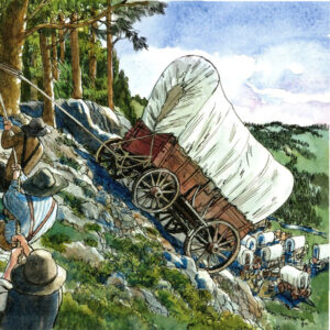
The hardest part of the Oregon Trail emigrants’ journey was the descent. In addition to the swampy bogs and dense forests, there was the infamous Laurel Hill. The pioneers mistakenly called the rhododendrons that were clinging to the steep slopes “laurels.” In places the grade on Laurel Hill was 60%–more vertical than horizontal. Here the wagons had to be slowly lowered with the help of ropes stoutly wound around trees. Described as “something terrible,” the slope was worn with ruts five feet deep. One wheel might drop 3 feet off a boulder while another dropped into a 2 foot hole. Wagons slid down the hill with all wheels locked and a 40 foot long tree tied behind for additional braking. At the foot of the hill, the tree was left to block the next wagon! Many commented that Barlow was wise to put his first tollgate at the east end of the road, rather than on the western side of the Cascades, below Laurel Hill.
However, the road was not profitable because many who used it could not afford to pay or were allowed to pass by a tolerant keeper.
Over the years, five toll gates were built to serve Barlow Road traffic from 1846 until 1915, when the right-of-way was willed to the State of Oregon and the last gate, near the town of Rhododendron, was removed. For its first fifteen years, the travel on the Barlow Road was one way—west—until a road was blasted out around Laurel Hill. With the Barlow Road open to traffic in both directions, it became a true thoroughfare, and emigrants were gradually displaced by stagecoaches and freight wagons. In the 1880s, it served the first tourists headed up from the Willamette Valley to vacation and recreation sites on Mt. Hood.
Traces of the original trail can still be seen today. A commemorative rock is located in Government Camp, and an Interpretive Center is available to shed some light on this important route.
In 1924, a highway survey discovered a Woman’s Grave, a pioneer buried in a wooden box. Since that time, people visiting the site have placed stones on her grave slowly building a monument to the early settlers passing the Barlow Trail. The site is located close to the current town of Government Camp.
The last tollgate operated on the Barlow Road (1879-1919) is the West Barlow Tollgate, located off Hwy. 26 between mile markers 45 and 46. A replica of the original gate stands between two maple trees planted by Daniel Parker, gatekeeper from 1883-1902.
On Hwy. 26 between mile posts 50 and 51 (access for eastbound traffic only), visitors can walk a short trail to view the near-vertical drop at Laurel Hill Chute where emigrants used ropes and sheer strength to lower their wagons down.
Jonsrud Viewpoint (Bluff Road, off Highway 26, in Sandy) provides a spectacular vantage point for viewing the portion of the Sandy River pioneers crossed on the Barlow Trail route over the mountains. Clear views of Mount Hood and surrounding areas are an added bonus.
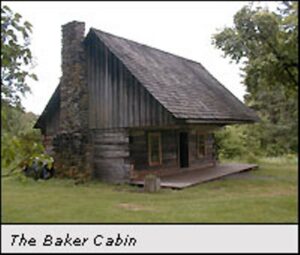
Experience the homestead life by visiting Baker Cabin in Carver, the only cantilevered log house in Oregon. The Baker family was part of the first pioneer wagon train to take the Barlow Trail toll road, arriving in Oregon City on October 10, 1846. Horace Baker opened a rock quarry and ran a ferry across the Clackamas River. After 10 years without building a house because of his busy schedule, neighbors took pity on his wife, Jane, and built her the house as it stands today.
Despite its failure as a financial venture, the Barlow Road played an important role in the early development of Oregon. It carried an estimated 75% of the early immigrants to the Willamette Valley and was described as the most difficult section of the entire Oregon Trail.
No Comments
Leave a comment Cancel