While traveling down the Columbia River on Sunday, November 3, 1805, Captain William Clark wrote in his journal:
“The Fog so thick this morning that we could not see a man 50 Steps off, this fog detained us until 10 oClock at which time we Set out, accompanied by our Indian friends who are from a village near the great falls.
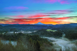
“The Quick Sand [Sandy] river appears to pass through the low countrey at the foot of those high range of mountains in a Southerly direction. A Mountain which we Suppose to be Mt. Hood, is S. 85º E about 47 miles distant from the mouth of quick sand river. This Mtn. Is covered with Snow and in the range of mountains which we have passed through and is of a conical form but rugid.”
Subsequently, “the Quick Sand River” was re-named simply the Sandy, and for a time a small town at its mouth was called Sandy. It was only when the townspeople decided to call it Troutdale that the present location was able to call itself Sandy, beginning with Sandy Post Office on February 13, 1873.
After wintering at Fort Clatsop, the Corps of Discovery headed back up the Columbia, beginning their long trek home. On April 2, 1806, they “came to a resolution to remain at our present encampment or some where in this neighbourhood until we had obtained as much dryed meat as would be necessary for our voyage.”
And where was that neighborhood? It had to be near the mouth of the Sandy, for Lewis writes of “the falls of a large river which discharges itself into the Columbia on it’s South side some miles below us.”
They called that river Mult-no-mah—we call it the Willamette—and Clark determined to take a small party and explore it, ascending to a point at or near the present site of Portland. While he was gone, Meriwether Lewis cooled his heels for several days, walking around describing birds, mammals, trees, and shrubs in great detail.
What would have been the historical impact if they had decided to go up the Sandy instead of the Willamette? Would Portland have become a suburb of Sandy? Would Sam Barlow have been met by a band of thriving settlers in Welches instead of Oregon City?
Would Joe Meek have called for a division of the house in Troutdale instead of Champoeg?
Probably not—after all, the Willamette was deep enough to make Portland a deep-water port, and its valley was a little more suitable for farming, but it’s fascinating to imagine how things might have been if Clark or Lewis or Sacagawea had said, “Hey, let’s see what’s up this Quick Sand River!”

No Comments
Leave a comment Cancel